By Sam Lunn-Rockliffe
*****
“He was given a permit. This meant he was permitted to graze his cattle in the open area, not to live here. His family and children were living down [on the escarpment]” – Thomas Kosgei Chelanga, Interview 30, 05.03.2017
Admittedly 11:00 am is a little early for a lunch of kichwa kwa kondoo (sheep’s head), especially after a litre of sweet chai and two chapattis for breakfast. However, the opportunity to interview our host for the day Thomas, the son of a community elder who I had previously spoken to on numerous occasions, was too good to pass by. What struck me during our conversation was his passion for delegitimising his father’s claim to the area in forest that his family had lived on prior to the 2013 evictions. As indicated by the above quote, Thomas repeatedly stated that his father Musa had not been born in the forest, but rather on the Elgeyo Escarpment that plunges down to the Kerio valley a few kilometres to the east. He had acquired a permit purely to graze his cattle in the forest glades and, like the other elders, had decided to take up permanent residence inside the forest against the Government’s permission. Thomas’s narrative is particularly unique given that he himself was born in the conservation area and has a stated interest in claiming land rights to his birth place. Yet he remained adamant that this was not his family’s original home.
It has been a year since I started field work in Embobut documenting the relationship that the Sengwer and Marakwet communities have had with their environment through time. Most community members I have interviewed over this period have different stories to tell of human habitation and family histories in the area. In order to untangle these narratives, a part of my methodology has focused on the material makeup of domestic space and settlement. Indeed, as one walks through the hills of the forest glade locally known as Koropkwen, a patchwork of old field boundaries and house platforms can be seen etched into the hillside. These are the remains of former households, spaces where individuals and family units carried out the tasks of everyday life at their most local level. Measuring between 5 metres and 20 metres, the housing platforms observable in Koropkwen were built as terraces in the hillside upon which houses can be constructed, a common practice used across much of the wider region. Since the 2013 evictions and the subsequent burning, collapse or cannibalisation of buildings, these platforms have become the main indicator of where people were living in Koropkwen and the Embobut forest at large. Platforms that are not completely overgrown with vegetation or disturbed by livestock occasionally display surface features of former structures, such as the foundation of stilted granaries, walls of houses and the relative location of hearthstones.
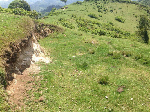
Old house platform
Mapping the location of these houses with community elders from three sample clans (extended family lineages) proved an insightful activity that helped illustrate how domestic spaces have changed over the past 100 years. Before people started farming in the 1960s, homesteads were typically located close to the Embobut river outside of the then thick forest and in the open glade. There were commonly two wattle and daub houses inside the compound, one belonging to the man and the other to his wife. Children slept in their mother’s house, whilst the man slept in his with his sheep and/or goats and the cattle were left outside in the compound. Once a boy was circumcised, he was no longer allowed to stay with his mother so either moved into his fathers or out of the compound entirely to start his own homestead.
As farming became prevalent in the latter half of the twentieth century, the makeup of this domestic space began to change. Newly circumcised men starting a family moved onto higher slopes away from the river where they cleared small patches of forest within their clan territory in order to grow maize. These compounds are reminiscent of those belonging to the neighbouring Endo Marakwet and agricultural Pokot, having a field system down slope of the house terrace and additional structures such as a granary for storing grain. Furthermore, most households had a hollowed-out log that was used as salt lick, acting as a trough that contained a mixture of salt, soil and/or flower for livestock. These came into use when bags of salt became commercially towards the end of the twentieth century and consequently meant that people no longer needed to take their cattle on a three-day hike to the Kerio valley every other month to salt licks.
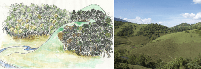
Fieldwork sketch of location of old Kapsaniak homesteads and forest as informed by interviews. Photo of the same location in the present-day.
After the 2013 evictions, people dispersed outside of the conservation area, building new households in neighbouring commercial centres. As such, many of the homesteads in Koropkwen became abandoned, collapsing into the observable ruins of today. Despite this, the glades still remain an important part of many people’s lives as they keep their livestock inside the conservation area. This has resulted in the flow of people moving in and out of Koropkwen on a daily basis and the appropriation of housing platforms by individuals wanting to tend to their livestock. Although people are not permanently living inside the conservation area, they do construct semi-permanent structures in order to shelter from the rain and periodically sleep in. Smaller than a permanent house, these shelters are not constructed to a high standard, some made only with bamboo and no soil, and others without walls at all. Makeshift materials such as tarpaulin and scraps of corrugated iron are also used as protection from the wind and rain. These houses are often built within or nearby the individual’s pre-eviction compound, occasionally hidden amongst vegetation in order to stay out of view from the Kenyan Forestry Service who periodically carry out raids and burn the structures. Outside of the shelter, the compound is divided into different segments in order to separate the sheep and cattle.
Tracing the material histories of housing platforms and settlement and how they have transformed over the past one hundred years has helped illuminate how people’s lives have changed. Of added interest to this is the notion that, whilst the three sample clans I worked with have a shared material history, how they identify is different. That is to say that each clan identifies under a different name; Sengwer, Marakwet or Dorobo. I do not have space here to delve into the history behind these terms, but suffice to say that the distinguishing of local identities in comparison to their shared material histories, perception of space and construction of landscape poses direct problems to notions of policy and rights to land based upon ethnic naming and minority rights.
