By David K. Kay
Walking down the Elgeyo Escarpment through Kacheseker village is always a tricky endeavour, as you head lower and lower the houses and fields become fewer, and the thorny scrub that much denser. The heat and flies also increase, with the simmering haze of the valley floor far below seeming to radiate the intense sunlight back up at you. Before long, the grassy swards and cool forests of the Cherangani hilltops seem like a distant, and much desired, memory. The Marakwet residents of Kacheseker rarely undertake this journey nowadays, though as little as 30-40 years ago it was a common activity, as people carried honey, dried meat and grain to the markets in the Kerio Valley, and led their cattle down to much-needed natural salt licks every three months or so. The new road network, and the availability of commercial salt, has more-or-less negated the need for these journeys, with once-busy footpaths slowly dissolving back into the shifting sediments of the Escarpment. Modern Kacheseker clusters on the Escarpment-top at Embobut, where the best agricultural land, infrastructure and, importantly, other people, are to be found. Over many sweaty weeks of hiking, however, my surveys revealed a pattern of settlement rather different to this modern scene.
Pushing through scrub and sliding down steep slopes, you periodically tumble onto a patch of suspiciously flat land. These little plinths litter the Escarpment below the modern village, and are the only remaining physical evidence of the population who once lived here. They are platforms that were cut out of the steep slope, on which people built their houses and arranged their domestic compounds. This building technique is still ubiquitous throughout the wider region, which makes recognising these old sites that much easier. In some cases, their stone revetment walls (telek in KiMarakwet) are still in evidence, clearly demarcating the old residences from the surrounding uninhabited land. Apart from maybe a few relict hearthstones, however, there is no other visible trace of the homes that once stood there; no house foundations, collapsed livestock pens or granary structures. These are all constructed from perishable materials, which upon abandonment are either recycled on other sites, or slowly disintegrate and perish. These abandoned sites are the current focus of my doctoral research, in an attempt to use investigative laboratory techniques to recover information on the spatial arrangement and use of these compounds, no longer visible to the naked eye. In the long run, this work will fit into the broader aim of assessing the changes in both domestic compounds and wider settlement patterns which have affected Kachseker over the last two-three hundred years.

Top: Site photographs of Chumo 03. Bottom: Close-ups of the collapsed house and its walls.
During fieldwork in the summer of 2017 I was able to sample four abandoned platforms on the Escarpment slope, taking both solid blocks and small loose bags of sediment from the compound surfaces to undergo geoarchaeological analyses back in the UK. These samples work in tandem, with the loose samples undergoing a variety of geochemical tests to assess broad patterns of horizontal spatial variation, and the blocks being prepared for micromorphological thin section microscopy to investigate the vertically-arranged deposits in specific locations. So far, I have been able to conduct preliminary analyses of both types on one the four sampled sites. This site (designated ‘Chumo 03’) is the old home of Barbellow, one of the key ancestral figures for Kacheseker’s contemporary inhabitants. It is hard to specify exactly when he built it, but extrapolating back from local oral historical testimony, he is likely to have lived there a little over a hundred years ago. It then lay empty and abandoned until one of his great grandsons reoccupied the site around five years ago, staying there for several years before leaving again two years before I arrived to sample it. This particular history of occupation, abandonment, re-occupation and re-abandonment is indicative of the mobility which characterises many local people’s lives on the Elgeyo Escarpment, leading to a fluid palimpsest of habitation within the broader historical trend of movement towards the Escarpment-top.
The advantage of beginning analysis with Chumo 03 lies in its modern re-occupation, as the sedimentary signatures left by this recent habitation are less liable to have been completely eroded from the site prior to sampling, particularly within the house structure of which the hearthstones and wall foundations are still visible. If productive, such analyses can then be feasibly applied to older sites in search of analogous signatures. Interpretation will thus ultimately span the whole set of sites investigated, with patterns and variations only attaining full value when considered across the temporal and spatial frame of the entire study. For the time being, the results from Chumo 03 will act as signposts towards this further inter-site goal.
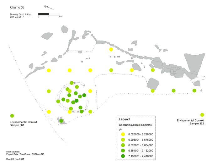
pH distribution across Chumo 03
Initial results from some of the geochemical analyses conducted across the platform of Chumo 03 have proved interesting. For instance, pH seems to be slightly more alkaline within the collapsed house, and mildly acidic across the rest of the compound’s exterior space. Whilst this doesn’t provide much resolution, it does suggest a possible means of identifying enclosed spaces of intense human occupation, i.e. houses, within the wider context of the surrounding ‘yard’. The concentration of phosphates is also greater within the house, as is to be expected given that phosphates concentrate through the accumulation of organic matter within the soil. Notably, the northern portion of the house is lower in this respect than the rest of the interior, suggesting less organic-input in this location. Although extremely tentative, perhaps activities such as sleeping were undertaken in this phosphate-deficient area, as opposed to tasks such as food preparation and consumption, which would be expected to leave greater organic residue in their wake. Elevated calcium carbonate content has also been clearly correlated with the ash deposits from the hearth, and so may prove useful in identifying relict hearths on sites where the hearthstones themselves have not been preserved. Geochemistry has thus been productive in identifying several putative means of identifying particular components of abandoned Marakwet homes.
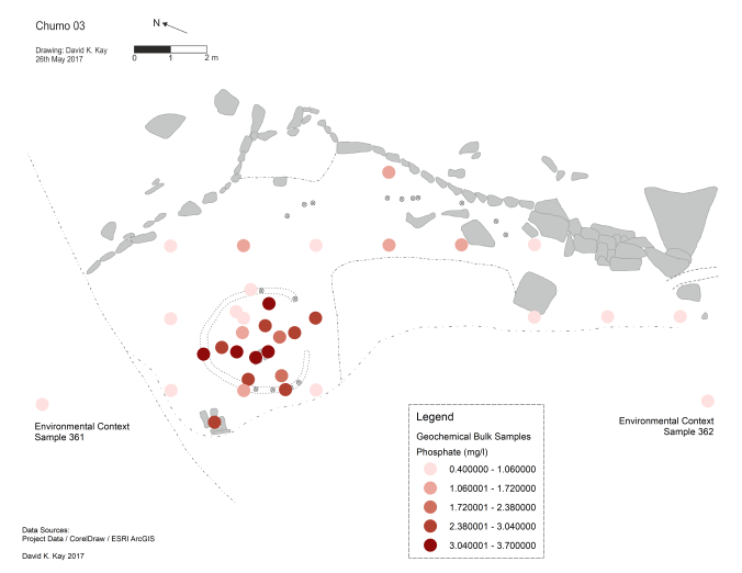
Phosphate distibution across Chumo 03
However, these techniques only address the cumulative record of the entire period of the site’s existence, and do not distinguish between distinct phases of occupation. This is where micromorphology can help, by looking at microscopic details of soil structure in small vertical blocks. Two of these samples were particularly interesting. One, Sample 308, came from just outside the presumed door of the house. Below a shallow layer of recent soil accumulation, a thin darker band can be seen near the top surface. Closer inspection shows that this band contains lots of iron, which has precipitated out as organic matter oxidises, and that the small particles of sand and silt are horizontally aligned. This is clear evidence for the trampling of organic waste into the soil, which we can infer relates to the passage of people in and out of the house during its latest occupation. Below this layer is another, thicker, build-up of ‘natural’ soil material, with a second darker layer below that. This second dark layer is again enriched with iron from organic sources, and the top of it displays a slight degree of horizontality. The working hypothesis is that this is the remnant of the external ‘trample zone’ from Barbellow’s earlier occupation. Recognising the existence of these two occupation phases within one sample is powerful indeed, suggesting that older abandoned sites without recent re-occupations may still retain the sedimentary marks of their original habitation.
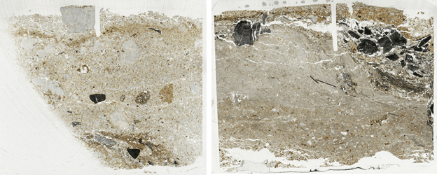
Left: Micromorphology Sample 308. Right: Micromorphology Sample 323
Sample 323 also contains hints of these two successive phases. In this case the sample comes from the ash deposits within the central hearth. At the top of the sample can be seen the charcoal from the hearth’s most recent use, after which it was never cleaned out. Below this is a layer of nearly-pure wood ash which most likely dates to the recent occupation and use of the house. Below this layer, another band of weathered ash with inclusions of soil material suggests an older phase of hearth use, i.e. the residue of its use when Barbellow lived there. Other samples reveal details of the destruction of the later house (it appears it burnt down), the building materials used in wall construction, and patchy accumulations of organic material across the floor. This technique in particular has proved very productive in both rendering greater detail on the house within Chumo 03 as it most recently stood, but also hinting at the physical trace of its preceding history. Within a few inches of soil, the imprint of over a hundred years of family history and movement across the Elgeyo Escarpment. What remains now is to connect other such imprints across Kacheseker, and begin to weave a more cohesive story of the history of occupation, movement and landscaping which its residents have undertaken within the span of the past few centuries of their cumulative lives there.
_____
David K. Kay
8th October 2017
Cambridge
